Line and Level Correlation Survey
We are an approved supplier of line and level survey mapping to Thames Water.
Methods available include:
Entry sewer:
- 3d laser scanning
- Total station mapping
Non entry sewer:
- Radio sonde
- Gyroscopic mapping – Reduct
- Drone
- Sahara survey
Deliverables include:
- 2D and 3D Line and level mapping in CAD to Thames Water standards
- Point cloud / 3D models
- OS19/21 sewer condition survey
- Photographic survey
Confined Space Working
When it comes to working in confined spaces, our highly skilled team have all the necessary experience, qualifications and equipment to carry out surveys safely and effectively.
All confined space works are carried out in accordance with confined space regulation using industry-leading safety and rescue equipment.
We’re able to supply clients with tailored, Thames Water compliant risk assessments and method statements. Our surveyors hold City & Guilds (6150-03) Working in High Risk Confined Spaces: Water qualifications and are trained to Thames Water Competent Person Level 2 (CP2) standard. They have extensive experience in large- and small-scale projects including line and level surveys direct for Thames Water and for developers, companies and individuals involved in ‘build near’ or ‘build over’ projects.
Frequently Asked Questions
What are line and level or correlation surveys?
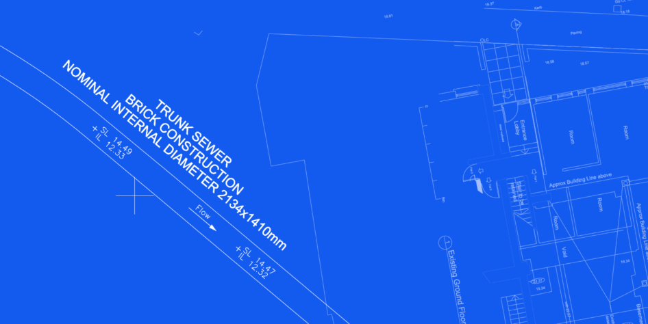
Line and Level or Correlation is a term used to describe any survey that confirms line (horizontal alignment) and level (vertical alignment) of a subsurface sewer, pipeline, tunnel or culvert. For example, a water utility provider may ask you for a line and level survey or correlation survey to confirm the position of a sewer or water main for a build over or build near agreement.
The term may also be used to describe alignment and orientation of above ground features such as road boundaries or to determine the elevation and height differences between points. This set of FAQs will specifically focus on (line and level) survey in relation to subsurface features such as sewers.
Why are line and level or correlation surveys important?
It is critical to map subsurface features accurately in advance of any construction project to plan for the protection of the assets and ensure the integrity of any new build.
Record drawings and old design drawings cannot be relied upon to represent accurate position. They can be useful as a reference to understand the approximate location of an asset and sometimes provide an approximate depth. They can also be used to understand the position of manholes / access points but should never be regarded as dimensionally accurate.
By conducting line and level surveys you will have the information needed to produce design plans that factor in the required easements to protect the asset. The surveys are essential for reducing risk and minimising potential issues during the construction phase. It may also be a requirement from the asset owner that you get a survey carried out prior to construction.
There are several techniques used for these surveys. It’s important to discuss with the surveyor the appropriate method to use on the asset you are trying to map and to understand the accuracy limitations.
What factors affect the success of the survey?
Different scenarios will mean the factors that affect success will vary. The technique will also be affected by different factors. Below is a general list of factors that may affect success, but not all are applicable in every situation.
A reconnaissance survey is one way to mitigate and plan for the below. We would always recommend this in sewer environments.
- Surveying challenges: Ease of transfer of surface control underground, 2 points of access (one at either end is ideal) the configuration and set up of these access point needs to be considered in advance.
- Depth of asset: The deeper the survey, the more difficult it can be to maintain accuracy. Measuring the depth of underground features like pipes and tunnels becomes more challenging with increasing depth. Again, this will vary depending on the method used.
- Flow level e.g water in sewer: The more water in the asset the more challenging the survey. Some techniques cannot be used in high flow sewers. On occasion flows can be reduced by the asset owner and out of hours works may be recommended as a solution.
- Condition of asset – sewers: Some sewers require cleaning. The level of silt and accessibility will affect how successfully this can be done. It is also a noisy process and is best completed during the day so as not to disturb neighbours. This presents a dilemma as we are more likely to get approval for traffic management (TM) at night. Inevitably a compromise is required that may involve more shifts of limited duration.
- Subsurface geology: Water levels, high clay soils and other ground conditions can affect the ability to locate sondes for example.
- Surface Terrain: The ground surface’s steepness, roughness, and irregularities can make it difficult to accurately measure line and level if using a method that requires surface detection.
- Vegetation and Obstructions: Dense vegetation, buildings, or other obstructions may make it difficult to get access to above to line.
What external factors effect the progress of the work?
See below some of the external factors what can impact on progress.
- Weather Conditions: Rain, Snow, or Fog: Wet conditions can make access to assets difficult and unsafe. High winds can affect equipment stability on the surface, especially with sensitive instruments like total stations, laser scanners or levelling equipment.
- Approvals and Permits: In some cases, asset owners will have systems in place for accessing their assets. Most will dictate the timeline but using approved suppliers who understand what is required will be able to comply and get the permits in place quicker. There may also be a need for permissions to access private or restricted land, which should be arranged by the client.
- Other contractors: If works are bring carried out on the asset in the same or another location may affect the ability to arrange the work to the required timescale.
- Traffic Management: If the access manholes are on roads controlled by a local authority or Transport for London (TfL) we must apply for the correct license to work on the highway. Their lead times; particularly for road closures; may be very long.