Legal
Independent advice from chartered land surveyors is essential for obtaining accurate, impartial survey drawings and reports—helping to clarify the distinction between physical and legal boundaries. Our legal and general surveying services can provide the expert guidance and support you need to go forward.
With extensive experience in boundary matters, we provide expert guidance and precise mapping to support dispute resolution. Our expert witness reports, compliant with Civil Procedure Rules (Part 35), can be used in legal proceedings where required.
What legal services can MJ Rees supply?
Working to RICS and HM Land Registry guidance, we provide the following services for a wide range of clients, including homeowners, property developers, solicitors, and estate agents.
- Lease Plans: Accurate identification, measurement, and marking of buildings or rooms, including shared areas and access routes. Digital Ordnance Survey mapping is also available upon request.
- Boundary Surveys: Clear definition of property boundaries, shared spaces, access points, and key structures such as substations or pylons.
- Written Reports: Includes a desktop analysis of relevant documentary evidence. This comprehensive approach allows us to provide a professional assessment of the situation, offering a clear and informed perspective to guide your next steps.
- Expert Witness: If a boundary dispute cannot be resolved amicably, litigation may be necessary this should be approached with caution due to the potential costs involved.
Also available is conveyancing plans, IPMS area referencing surveys, and setting-out services.
Need help with a boundary dispute?
Understanding your property’s boundaries is crucial in avoiding disputes. The Royal Institution of Chartered Surveyors (RICS) provides a helpful guide on topographic surveys and boundary disputes.
Frequently Asked Questions
What are the main differences between legal and general surveying?
Legal Surveying: Focuses on defining property boundaries, resolving land disputes, and creating official land records. It ensures compliance with land ownership laws and regulations. It can also have direct legal consequences; its results are used for property deeds, court cases, and government records. Using a chartered surveyor for legal surveying in the UK is recommended for the following reasons:
- Chartered surveyors have in-depth knowledge of land law, boundary disputes, and property rights.
- Their reports hold legal weight in court and are used as expert witness evidence in property disputes.
- They can provide RICS-compliant reports, which meet the standards of the Royal Institution of Chartered Surveyors (RICS).
- They understand planning regulations, easements, and restrictive covenants, ensuring accurate legal interpretation.
- If a dispute escalates to court, a chartered surveyor can act as an expert witness to provide professional, impartial evidence.
- Their testimony carries significant weight in legal proceedings.
General Surveying: Encompasses a broader range of surveying activities, such as topographic, construction, engineering, and hydrographic surveys, used for planning and design rather than legal purposes. Regulated chartered surveying firms that follow the Royal Institution of Chartered Surveyors (RICS) guidelines will provide a professional service with quality assured data.
When might you need a legal survey?
You might need a legal survey or land registry compliant plans in several situations where it’s crucial to have an official and legally recognised determination of property boundaries, or other related factors. Here are some key scenarios when a legal survey is required:
- Buying or selling property
- Building or construction projects
- Disputes over property boundary
- Establishing easements and rights of way
- Obtaining permits
- Subdivision of land
- Title insurance or financing
- Property inheritance or estate planning
- Insurance or risk management
- Land development
- Impartial survey requirements
Why should you use a RICS chartered land surveyor?
Overall, working with a RICS chartered land surveyor gives you peace of mind, ensuring your projects are professionally managed and compliant with relevant standards and regulations.
Key benefits include:
Professional Standards and Expertise: RICS chartered surveyors are highly trained professionals who adhere to a strict code of ethics and professional standards. Their knowledge and expertise ensure that they deliver precise and dependable survey results.
Accurate and Reliable Surveys: Chartered surveyors are skilled in using advanced technology and methods to carry out land surveys, paired with robust quality assurance procedures which helps to ensure that the data gathered and processed is precise and trustworthy.
Legal and Regulatory Compliance: A RICS chartered surveyor is well-versed in the legal and regulatory requirements of land surveys. This ensures that their work is compliant with local laws, planning regulations, and construction standards, helping to avoid legal issues down the line.
Risk Mitigation: Hiring a RICS chartered surveyor can help identify potential risks early on in a project. Whether it’s uncovering land disputes, boundary issues, or hidden environmental concerns, their expertise can save you from costly mistakes or delays.
Objective and Independent Advice: Chartered surveyors provide impartial and objective advice, as they are independent of any property transaction or development process. Their role is to give you accurate assessments, free from bias.
Insurance and Liability: RICS chartered surveyors typically carry professional indemnity insurance, offering you protection in case something goes wrong with the survey or advice provided. This adds a layer of security and reassurance to the work they perform.
Accreditation and Recognition: RICS is an internationally recognised institution. A surveyor with this credential has undergone rigorous training and assessment to prove their competence in their field, offering you confidence in their abilities.
How do I obtain a land registry compliant title plan?
Send a marked-up plan or drawing (this can be a google image with a red line) and the site address to survey@mjrees.co.uk to show the area you need surveying, and we will reply with a quotation.
The process will involve the following steps:
- Quotation submitted
- Order/go ahead received
- Onsite survey (measurements of required features surveyed)
- Office processing
- Final delivery
How can a land surveyor help with a boundary dispute?
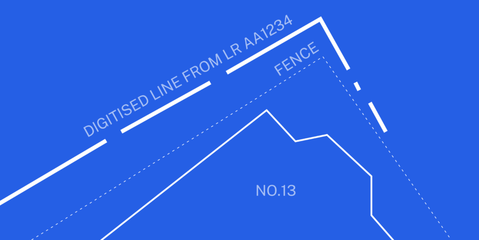
A good starting point for resolving any boundary dispute is to get a dimensionally accurate plan to present the facts. A land surveyor can help with this. They will use specialist surveying equipment to survey onsite features to produce an accurate drawing in CAD. We can then use this drawing to compare the boundary lines shown on existing land registry plans.
If necessary, the comparisons can then be analysed and a report written by the chartered surveyor advising on the survey and important findings. The latter must, and always will, be completely independent.
If a dispute escalates to court, a chartered surveyor can act as an expert witness in court to provide professional, impartial evidence.
It’s useful to note, Courts look favourably upon the use of joint experts by both parties.
Get in touch
For professional, reliable legal and general surveying services, contact us today to discuss your requirements.